Overview of The Quilotoa Loop:
Within the Andes of Ecuador likes the Quilotoa loop. Trails and dirt roads lead you between the various villages of Ecuador all while providing some of the most amazing views. While the you can’t hike the whole loop you can certainly hike a small portion of it over 3 days and cover some good ground. On your way you will meet plenty of the indigenous folk living in the mountains and get barked at by plenty of dogs. This is the hiking highlight of Ecuador so don’t miss it! It is completely safe and no guide is required if you use our trial guide below.
Note: This guide is for Sigchos to Quilotoa, if you are looking for the reverse CLICK HERE!
Local Lodging:
- Latacunga:
- Budget: Hostal Cafe Tiana through HOSTELWORLD.COM
- Splurge: Villa de Tacvnga Hotel through HOTELS.COM
- Isinlivi
- Budget: Hostel Taita Cristoball
- Splurge: Hostel Llullu Llama
- Chunchilan
- Budget: Cloud Forest
- Splurge: Mama Hilda / Black Sheep Inn
- Quilotoa
- Budget: Hostal Chukirawa
- Splurge: Hosteria Alpaca Quilotoa
Time and Cost:
- Entrance: Free
- Time: 2-3 Days
- Distance: 37KM/22 mi
- Trail Type: One Way
Equipment Needed:
- Water
- Sunscreen
- Spending Money
- Snacks
- Packed Lunches
- Small Backpack
- Clothes for 3 days
- Camera
- Rain Coat during the rainy season
Getting In:
Those doing the Quilotoa loop will find it easier to stay in Latacunga the night before. Here you can store your large bags and only bring the essentials you need. Latacunga is a nice town as well, however you won’t need much more then a day to explore it. Use the time to pack up on essentials and decide what bus you want to take in the morning. Your hostel will have the bus times to Sigchos, as well as return times from Quilotoa.
All accommodation on the Quilotoa loop provides both breakfast and dinner. You can get lunch on the first day when you get to Sigchos, or bring your own packed lunches and snacks for the trip.
Trail Guide:
Day 1
Sigchos to Isinlivi
Time: 3-4 Hours
Distance: 14 kms
Unmarked Trail
The bus from Latacunga will head strait up hill and drop you off towards the top of the top of town. As you get off the bus you will notice that the town is surrounded by hills on 3 sides. Turn around from where the bus dropped you off and you should be facing the opening side of town, which isn’t surrounded by a mountain. Head towards the bottom right side of town until you reach the signs for Chungchilan and Isinlivi. Take the road towards Isinlivi and ignore the road to Chungchilan. Right after leaving the village you will see another sign for Chungchilan to the right. Ignore this road and keep heading strait to Isinlivi.
Shortly after you will come to an unmarked fork in the road. You will head towards the right and you will start winding down into the valley. Depending on the time you will likely pass a few locals as well.
As you wind down into the valley you will pass a church on your right. Continue along past the church ignoring the road directly after it. Next on the right side you will then pass an uphill grass driveway, ignore this also. Instead take the next road on the right hand side that is slightly uphill then strait. It should be directly in front of you. Take this and you should now be on a dirt road in between farms. As you walk along the road you will notice a few farms up on the right hand side.
As you continue along the road it will start to curve to the right and go up hill. Here you will notice a small unmarked trail off to your left going down the mountain. Take this trail down until you reach the road. As you come out onto the road you will see a large empty swimming pool. Next you will turn right and continue along the road.
Continue along the road until it starts to curve to the left. Before the curve you should see a trail on the right hand side leading once again down a hill. This trail should be directly in front of you. Take this and continue down the hill until you one again hit the road.
As you come out onto the road you will see a stone bridge to your left. Ignore this and head to the right. As you continue along this road you will pass about two houses on your left hand side. Right after the second house, and before the road curves uphill to the right, is a grass driveway on the left you must take. Go along the driveway and onto the trail where you will see a concrete footbridge and pass over the river for the first time.
Walk along the bridge and head to the right along the riverbank where you will notice a small footpath heading up a semi steep muddy hill. Take this footpath until you reach the road and then turn left, walking along the road once again.
Continue walking along, passing a school and a church. Shortly after the road curves to the left and you will see a trail heading up and to the right. Take this trail and head upwards till you reach the next road. This trail is more or less up hill and will take sometime to complete. Enjoy the views of the town and the valley you just conquered as you head to the top.
Once you reach the road you make a right and you are now on the road to Isinlivi. From here it will be about a 30-45 minute walk along the road till you reach Isinlivi.
As you reach town you will see an intersection before the Church, turn right here. Then at the next intersection make another right. Here you will see two hostels. Hostel Taita Cristoball and Hostel Llullu Llama. The first being the cheaper option.
Day 2
Isinlivi to Chugchilan
Time: 4-6 Hours
Distance: 12 kms
Semi Marked with Red Paint
Note: There are a few bits on this trail marked by red paint. You will see it more often later in the trail however it reassurance knowing you are going the right way when you see the paint.
Head to hostel Llullu Llama and make a left before the entrance down the trail past the kitchen window. Follow the trail down the hill ignoring all trails going left or right. As you approach the river you will see a bridge crossing on your left and a large rock to your right. Ignore the bridge and follow the trail around the rock.
Follow the trail to the right of the river crossing a small log bridge as you head downstream. The path inclines a bit then stays more or less level. As you go along the path you will come across a farm directly in front of you. Here you turn left and follow the trail through the pasture. The trail is pretty faded walk through the pasture up to the right hand side. Once you approach the upper end of the pasture you will see the trail continues off to the right, take this trail.
Continuing onward you will reach your first fork, keep left and don’t go down hill. Right after is another fork where you keep right crossing over a small stream (Note: This may be dried up depending on the weather). Continue onwards as you descend between cliffs. However, very soon you will have to take a trail to your left. If you look UP you will see some electricity cables crossing the trail on your left. Make sure you directly UP as they are easy to miss, otherwise the trail will curve right and you will descend into the canyon and continue the wrong way.
Once you follow the trail to the left continue walking for about 30-40 minutes absorbing the views of the canyon and the white cliffs along the trail. Once you pass the cliffs and they are now on your left hand side you will reach a fork. To the left goes uphill and to the right goes down hill. You take the path to the right which brings you down to the river.
Note: A lot of the guides we see mention another fork before hand or a 180 degree turn with a fork t0 the right. This can be ignored as the path was blocked when we saw it. You will notice a speck or two or red paint when taking the path down to the river, reassurance you are heading in the right direction!
As you continue along the path you will pass a wooden gate, walk around this and continue onwards. Once you reach the stoney riverbed head left and continue upstream on the left hand side of the river. The trail fades and isn’t very visible, but keep heading upstream and you can’t get lost. As you continue you will reach a large clearing with very large eucalyptus trees in the back and a few knee high rocks around you. Walk through the field and you will see a very large log bridge with handles, cross this and head left upstream.
Follow the path up the river going through any fences along the way. Soon you will approach a suspension bridge on your left, don’t cross this but continue onwards. Shortly after passing the suspension bridge you will see a path going right up into the hills, take this path. Once you reach the fork continue left until you reach the road for village Itualo.
Walk through the village and take the road to the right of the church. After a few minutes you will reach a fork, go right and continue on the road up the hill to what looks like a water reserve. After this there will be a path off to your left that goes up the hill. Follow this path of about 15 switchbacks all the way up. Once at the top you will reach the town of Chinalo.
At the top of the hill you turn left and continue to follow the trail. There is a nice mirador in Chinalo though if you want to see the valley you just climbed up and walked through. Otherwise, follow the trail until you reach the road. Here you make a left and follow the road for about 45 till you reach Chugchilan.
Day 3
Chugchilan to Quilotoa
Time: 6-7 Hours
Distance: 11 kms
Unmarked
Note: Most of this journey is uphill, and some travelers will say to start the whole trip in Quilotoa because of it. It isn’t that hard but you should be prepared with water and snacks. We’ve done both ways and I always preferred this way as you end your 3 day hike with amazing views rather then an empty town. It just makes the whole hike that much more worth it.
Leave your hostel and walk through the village of Chugchulin. You will pass through a main square, the church and then approach a library on the left hand side. Here is a big sign showing the trail to Quilotoa. Follow the street down to the left for about 5 minutes. Here you will see another street going sharply to the left. You can take this street or follow the near by trail. The choice is yours as they meet up shortly.
After about 15 minutes from either choice you will see a trail down to the left of the road. Take this trail directly down as it leads to the bottom of the Rio Toachi Canyon. Use the small bridge to cross the river and get ready for the ascent for the rest of the day. Follow the trail that goes off to the left and head upwards until you reach the lookout points. After some pictures take the only road into the town of Guayama.
As you enter the town of Guayama you will see two roads heading parallel to your right through the center of town. Take the second road right past the local cemetery. Keep following the road through town and the intersections. After you pass the last shop you see some fields in front of you follow the road to the left and continue upwards. Once you reach the end of the road take a left and then take the first right onto another road.
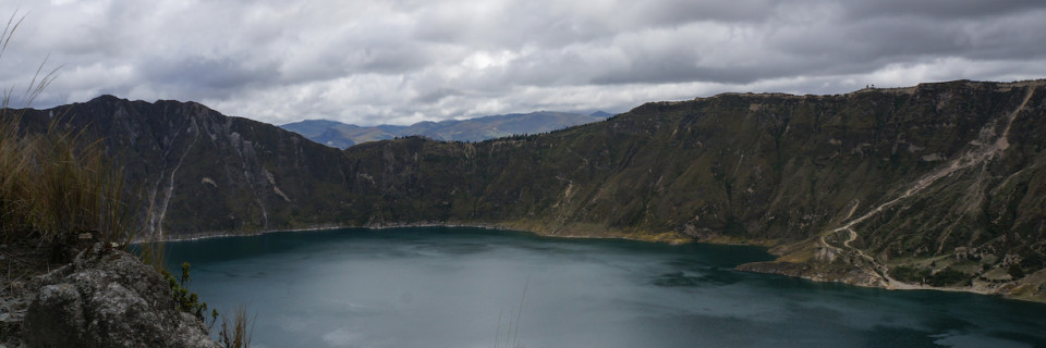
You will now stay on this road till you reach the crater rim. This walk will take a few hours as the road gradually climbs up to the crater rim. Once you reach the rim you will have an amazing view of the crater and an option to go either left or right.
Heading left will take about 3.5 hours to get to the town of Quilotoa. Heading right will take about an hour. Which ever option you choose make SURE you stay along the rim of the crater. Don’t take trails heading into the crater or outside the crater. We did this our first time and it is NOT fun. If you follow the trail to the right head up that small peak, not the trail to the left that goes into the crater.
After arriving in town you have the option to stay the night or take the bus back to Latacunga. Quilotoa gets very cold at night and is pretty expensive compared to the other towns. If you get back to late for a bus so go to the indoor market / information stand ask for a Taxi / Ride Share ($6) to Zumbahua. Here there are multiple ways to get back to Latacunga. Either a ride share in the back of a box truck or a bus. ($1-2).
![]() About Savvy Travel Secrets
About Savvy Travel Secrets
Savvy Travel Secrets is a group of authors that travel the world to explore everything the earth has to offer. We are now sharing our savvy traveling secrets with you! Experience your own memories using some of our ideas to help make traveling cheaper and easier!
10 Comments
Hi. Thrifty drifter here. Great job with getting in all those little details that makes it easier for travelers to overcome their inhibitions and try something like this. It’s a beautiful hike in a beautiful country, that’s for sure.
Great info. We are a mature ( ha!) couple that plan on hiking parts of the loop this Sept. Do you happen to have this info in reverse? Quilatoa to Chugchulin to Isinlivi? That would be great. Thanks so ,much.
Hi! Actually I do, I will type it up and post it this week! Be on the look out!
Fantastic! Thanks again.
Leaving in about 10 days. Reverse loop completed by any chance? Thank you very much.
BJ COLLIER
Hi BJ, I actually just found all my notes on the reverse today! I’ll type it up and make sure you have it before you leave!
That will be wonderful. Thanks again!
BJ
Hello! Have I missed the posting of the reverse loop? Thanks a lot.
Congratulation for this good job, especially for this unusual Sigchos to Quilotoa way. clearly the best source I’ve been reading till now.
Concerning the Chugchilan to Quilotoa segment, you indicate 6-7 hours walk. I understand that it Is by walking on the Quilotoa rim on the right side (1 h).
But I would appreciate your confirmation.
Fabrice
Hi Fabrice,
Yes, this is to the right side. The left side adds another three hours or so. Happy hiking!!
Cheers,
SavvyTravelSecrets