Ben Nevis is the highest peak in the Great Britain and part of the three peak challenge! The three peak challenge consists of hiking the three highest peaks in Scotland, Wales & England in 24 hours. While thats a bit crazy it is fun to do on a long weekend! The path to the top is well marked and often called the Pony Track. Ben Nevis is the highest, longest and hardest of the three peaks but the views make it so worth it.
The easiest way to get to Ben Nevis and also doing the three peaks is by hiring a car. However, if you only want to hike Ben Nevis then take a train up to Fort Williams, the closest town. Here you can take the local bus or walk to the Glen Nevis Visitor Centre. There are no direct buses, however you can get one that drops you off near by. Check the time tables at the rail station or ask there for more informations as the bus schedule changes frequently.
You should start your hike as early as possible as the weather can quickly change and often it can get dark very fast. The visibility is low at the top of the mountain so the more light you have the better. Summer months are the best due to the snow that accumulates at the top of the mountain during the Fall and Winter.
The trail to the top of Ben Nevis is commonly referred to as the ‘Tourist Route,’ the ‘Tourist Track’ or the ‘Pony Track’. The Pony track is the simplest way to toe the of the mountain as well as the most popular.
From the tourist center, walk towards the opposite end of the car park and follow the bridge to the start of the path. The path is very well marked and very visible for the first half.
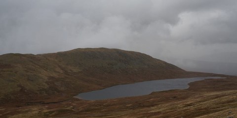
Half way up, at Lochan Meall an t-Siudhe, the path is mostly rock. The rocks get wet and often the visibility is low at the top depending on the weather. Be careful as it is easy to trip and twist and ankle or even worse. Once you reach the top you will see the old abandoned observatory as well as a World War 2 memorial.
Once you are ready you take the same path down, sticking to the trail and watching out for slippery rocks on your descent.

Europe